Tuesday, September 30, 2014

Invasive Carp on the Illinois River

Hey Paddle Forward!  My name is Emily Knudson and I am a student at Augsburg College majoring in Environmental Studies and Spanish.  I was on the 10 day Mississippi river trip with Liz and some other students who have been posting to this blog, and on that trip we heard a lot about Invasive Asian Carp.  The paddlers on the river have had an experience with an Asian Carp hitting their canoe, and Nick Ryan posted last week about how he heard about an electric underwater Asian carp barrier, so I decided to see what I could find about Asian carp on the Chicago River.  

As my classmate Rachel mentioned in her previous blogpost, due to waste water and pollution contaminating the water supply intake point in Lake Michigan, it was decided that the direction of the river flow must be reversed.  Engineers completed the Chicago Sanitary and Shipping Canal in 1871 which linked Lake Michigan and the Chicago River, effectively reversing the flow of the river and flushing the waste and pollution away from the city.  An unintended consequence of this action was that the two distinct ecosystems became connected, creating a pathway for invasive species moving in both directions.  Ironically, the water quality in the Chicago River was so polluted that invasive species were unable to spread to this ecosystem.  

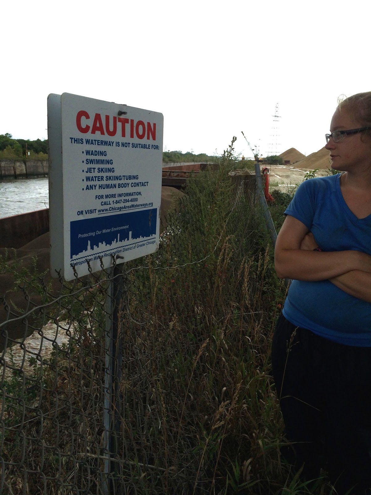
In recent decades the Chicago River has become a lot cleaner, and although it is still too polluted for humans to swim in or even touch, Asian carp have adapted to this ecosystem.  The Asian Carp are an invasive species originally imported into the United States to control algae growth in Southern fish farms in the 60’s and 70’s.  Since then have moved up the Mississippi majorly disrupting the native ecosystems and outcompeting native species.  Carp are filter feeders that can grow up to 50 pounds and filter the water so thoroughly that there is not enough food for the native species.  If carp swim up the Chicago River (as they are currently doing) and get into Lake Michigan, the lake’s native species will suffer greatly and the carp will have to opportunity to spread to even more bodies of water.  

The carp have now moved within 50 miles of the lake, but an underwater electric fence has so far halted their advancement.  The U.S. Army Corps of Engineers constructed the electric fence under the canal in 2002 and it is the first of its kind to be implemented.  The U.S. Fish and Wildlife service annually completes “carp corral” surveys and has recently noted that at 100 miles downriver from the lake, the Carp population has more than doubled in just one year.  While completing the surveys, the movement of the boats stirred the carp causing them to jump out of the water with such velocity that they have broken surveyors noses and damaged boats.  

The electric fence is made up of bundles of steel cables that stretch along 54 feet of the canal, releasing one volt of charge per square inch of water.  If people were to touch the water with their hand they might feel a tingle or nothing at all, but the Corps is still trying to determine what would happen if a person were to fall into the water.  Although research is being done to discover what would happen if someone fell in the river, it is somewhat alarming that they have already begun using this technology without fully knowing the consequences it could have.  So far the barrier has prevented carp from moving any farther upriver, but other ecological impacts of the electric fence are still being studied.  


A silver carp jumped into one of our boats...watch this video!

Tuesday, September 23, 2014

Augsburg Post: Water Quality

Hey there Paddle Forward! My name is Rachel Shaheen and I am senior at Augsburg College studying Biology, Environmental Studies, and Music.

Unfortunately, I was not able to go on the ten day trip down the Mississippi with the rest of the class and Liz, but I hear it was an amazing experience. Even though I didn’t make it on the trip, I am no stranger to canoe camping. I grew up in Northern Minnesota and have spent a lot of time camping in both the Boundary Waters Canoe Area Wilderness and Canada’s Quetico Provincial Park.

One thing that really interests me about your trip is the quality of the water you are paddling through. Growing up camping in Minnesota I was spoiled with incredible clean lake water. You can drink from most of the lakes in the BWCAW, so I can not imagine what it would be like to canoe through a river where you cannot drink from, swim in, or even touch the water. I was shocked to see the picture you posted of the sign cautioning against any human body contact with the water, and it made me curious about the river’s history.The city of Chicago has an interesting story when it comes to their wastewater management.

Located near the intersection of Lake Michigan and the Chicago River, the city has historically used the lake for both drinking water and waste-water disposal. In 1852 Chicago installed a combined storm-water runoff and sewage system underneath the densely populated areas of the city.

This became a major health concern when the pollution from the waste water reached the water supply intake point in Lake Michigan. In order to solve this problem the city of Chicago considered reversing the direction of the Chicago River, so instead of flowing into Lake Michigan the river flowed into the Illinois River, and eventually into the Mississippi. Construction began in 1865, and by 1871 the flow of the river was formally reversed. The reversal of the river greatly benefited Chicago by significantly decreasing the deaths due to Typhoid and other water-borne illnesses. But while the residents of Chicago benefited, the residents living in the Illinois River basin paid the costs. Eventually, this issue was brought to the U.S. Supreme Court by the state of Missouri in 1900, but they were unsuccessful in stopping the discharging of water into the Illinois River.

In the 1920s Chicago transitioned from an open-sewer system to a waster water treatment system with the construction of four major sewage treatment plants. As new treatment plants were built to accommodate a growing population, Chicago quickly became the home of the largest waste water treatment facility in the world. Despite these treatment facilities, the Chicago River is still considered one of the most threatened waterways in the country, with approximately 1.2 billion gallons of partially treated wastewater being dumped into the river every day. This is because the treatment plants do not use a disinfecting technique that is used by other major cities in the U.S.. Most treatment plants use two basic stages when treating wastewater. In the first stage of treatment solids are allowed settle and are then filtered out of the water. In the second stage of treatment biological processes are used to further disinfect and purify the water. This second stage is very important because it removes bacteria and other organisms that carry water-borne illnesses. Although the EPA has pushed for a cleanup of the Chicago River, the Metropolitan Water Reclamation District is doubtful that the cleanup efforts will be worth the costs (roughly 427 million dollars). 
river.jpg

Sunday, September 21, 2014

The River from the Road

Isle a la CacheThere was a sign along a back road on my way to Lockport, IL which said, “Isle a la Cache Museum.” What an invitation! I followed the sign. I pulled down a road leading to the Sanitary and Ship Canal to check out some construction I saw going on. I drove down the road towards an open gate leading down to the shore of the Canal. Signs on the fence announced that this was to be the permanent site of an electrified, underwater Asian carp barrier. This was my lucky day! I lurched over potholes to pull up next to a pick up truck sporting bumper stickers of the People Eating Tasty Animals variety. The truck was parked next to a trailer at the top of the south Canal shore precipice (the Canal was bordered by 8 foot tall limestone walls). I hailed the owner of the truck to ask where I could find some information on the barrier. He mentioned that I could drive over the bridge to the other side of the Canal and speak with the Army Corps Director of Operations, John McGowan. The construction worker mentioned that work had been slow due to heavy rains. I thanked him for the information and hopped back in the van towards the other shore of the Canal. I drove up to the considerably larger construction operation on the other side of the canal and asked another worker where I could find the Army Corps Director of Operations; he directed me towards the far end of the site and a trailer which resided there. I brusquely walked through a gate lined with, “No Trespassing: US Government Property,” signs and knocked on the door of the trailer. No response. I knocked again and louder this time. Still nothing. I shouted, “is there a John McGowan here.” Unfortunately, I was unable to reach anyone with the Army Corps of Engineers at the barrier site; not for lack of trying.Carp Dispersal Sign
I closed out that particular side mission and got back on the short road to the Isle a la Cache Museum. I found the museum building nestled on an island between a split in the Des Plaines River. A beautiful location. The museum highlighted the relationship between French fur traders and Native Americans. As I was leaving the museum, the paddlers pulled up just outside the museum so I stuck around for lunch before heading out to Lockport. I scouted out the river near Lockport for somewhere the paddlers could pull off the river and get into town. Once again I was disappointed. There was no easy access to the Des Plaines River from Lockport.
JolietA lack of access to the river has become a theme for my journey on the roads paralleling it. Recreation along and within the river seems to have been forgotten, along with any connection to it. The city planners of Lockport, Romeoville, Lemont, or even the larger city Joliet did not involve the Des Plaines River in any way that I have noticed. Joliet exemplifies this exclusion as it is the first city to straddle the river on both sides since Chicago. I was fully expecting a large city park highlighting the Des Plaines River and Joliet’s rich history. At least some mention of the town’s namesake. There was a statue of Louis Joliet outside of the Public Library in town but nothing noticeable beyond that. It feels as if these towns are ashamed of their association with the river. And considering its present state, I am ashamed for them.
A healthy river reflects a healthy community. The vice versa, of course, is true as well. When a river system’s vitality gets ignored or, in the case of the Chicago and Des Plaines Rivers thus far, experiences active degradation from the surrounding communities. It hardly stands a chance.
Nick Ryan, Paddle Forward Support Team

Augsburg Blog: Indigenous People

Oh hey there Paddle Forward crew!! My name is Lily Moloney and I’m a chemistry major at Augsburg College. I moved to Minneapolis, MN three years ago when I started school but I am originally from Iowa City, IA (home of the Hawkeyes and lots of corn!). At the beginning of this semester I had the pleasure of exploring the Mississippi River for ten days with my class and Liz Just, who told us all about your trip. It has been really fun following you guys and comparing your experiences with my own.
On our trip, we stopped on Prairie Island (which isn’t an island anymore, due to channelization…but that’s a whole other story) and talked to Paul Dressen, director of education, about the Indian reservation that is located on the island. Prairie Island reservation is home to the Mdewakanton, which means “those who were born of the waters.” The Mdewakanton have done a tremendous job of restoring prairie fields.  They have also partnered with The Inter Tribal Buffalo Council to bring back the buffalo.
You guys started your trip in Chicago, IL, which is home to over 49,000 Native Americans who represent over 100 different tribes. This may seem like a very large number, but before the European Invasion, Chicago was home to several powerful tribes, including the Potawatomi, Maiami, and Illinois, and now they are outnumbered by nearly every other ethnic group.
After the European Invasion, the Indian population in the Chicago area dwindled down to almost nothing. Then in the 1900s, the population began to rise again when many Native Americans moved from rural neighborhoods and reservations to urban areas, such as Chicago, in pursuit of jobs and other opportunities. This move was also partially because of the government relocation program in the 1950s. Moving to the Chicago area was a scary time for many Native Americans, but they found comfort in social clubs that they formed. The growing population and the formation of social groups lead to the American Indian Center, which w as established in 1953. In the 1960s and 70s several more large organizations were formed when civil rights and social issues were prominent and funding was available.
After the 1970s, the number of American Indian organizations kept increasing till around thirty years ago when they maxed out at a little over twenty. These organizations inform people of American Indian history and culture as well as being involved in a variety of community needs and interests including, education, health, and arts. Unfortunately, the organizations' funds have been cut by the city and federal government due to the recession that began in 2008. The 20+ American Indian organizations dropped to around 3 organizations.
The Indigenous people chose the land you are traveling through because of its riverways. The Chicago and Illinois rivers connect the Great Lakes with the Mississippi, making them very useful for trading. The river also is a great source of new water among its many other uses. For these reasons, the Native American community was tied closely with the river. Sadly, today's Chicagoans (including the Native Americans) have little connection with the river because it's mostly for large-scale commercial use.

Hope you guys find this helpful and interesting!
Lily Moloney
Augsburg College

Des Plaines Days

We left Chicago excited about paddling the Shipping and Sanitary Canal, located about 20 miles south of Downtown Chicago.  However, after talking with some locals, calling multiple people who called other people who then called us again, and talking with the U.S Coast Guard, who just happened to be boating past, we quickly realized this was not going to be feasible.  There were several barriers (literally) preventing us from being able to paddle the canal.  First, the canal is constructed from huge limestone walls that at times are 10+ feet above the water level, preventing quick access out of the canal.  Second, the Army Corps of Engineers built several electric barriers to prevent the spread of invasive carp traveling through the Canal into Lake Michigan.  You can’t safely travel through the barrier in boats smaller than 20 feet (our canoes are about 17 feet) and we learned our only option was to portage 2 miles around the barriers if we were going to paddle the Canal.  I’m glad the Army Corps is taking steps to prevent the spread of Asian Carp.  However, I was disappointed to learn they didn’t think about paddlers in smaller boats coming from Chicago that may need to travel around the barriers.    
With electric barriers and limestone walls preventing us from paddling down the Canal we decided our next best option was to launch from the Des Plaines River paralleling the Shipping and Sanitary Canal.  When we arrived, we were happy to find a nice place to launch our boats on the edge of a prairie preserve.  A man approached us who was there with a group picking up trash in the area.  He told us there is a group of volunteers maintaining the small picnic spaces in the area along the edge of the preserve by the water.  He said his hope for the area was to provide a nice spot where anyone could come down and enjoy the water.   
The group before we launch for our first day on the Des Plaines River
During our days on the Des Plaines we experienced the contrast between beautiful natural spaces and industry on the Des Plaines.  We had stretches of paddling where we were overwhelmed with the beauty of the River.  Egrets, Kingfishers, Cormorants and Blue Herons were frequent visitors on the river bank and large stretches of the river included beautiful prairie, forests, and wetlands.  We enjoyed running (a term used to describe paddling through rapids) the multiple rapid sets that we unexpectedly found ourselves encountering.  Dispersed among the stretches of seemingly pristine landscape we paddled among power plants, railroads, and other industrial buildings. 
Randomly as we paddled we would be reminded of our proximity to the Shipping and Sanitary Canal when the wall of limestone would creep into view on the left side of the river bank.  Sometimes we could see a barge peaking over the top of the wall.  Once, we approached the wall and noticed we could climb up the rocks on the bank to look over and see into the Canal.  When we arrived at the top, we were surprised to find we were standing just upstream from the Lockport Lock and Dam.  I felt strange looking into the concrete walled space of the Lock and Dam after being on the Des Plaines.  I can remember feeling like I was looking into a prison for water, lacking any plant life and beauty.  I was thankful to return back to the Des Plaines and paddle among the trees and birds.       
The Lockport Lock and Dam from on top of the Canal

- By Liz Just

Wednesday, September 17, 2014

Risks on the River

There are inherent risks associated with river recreation, which all of the Paddle Forward expeditioners have experience managing. For this reason, we always wear PFD's and are careful around the water while paddling, recognizing and respecting its great power. The Chicago River and Des Plaines River present a new hazard that I have never had to think about during any paddling I have done in the past. The water itself is a hazard. All along the way there are signs that say:

CAUTION
THIS WATERWAY IS NOT SUITABLE FOR:
  • Wading
  • Swimming
  • Jet Skiing
  • Water Skiing/Tubing
  • Any Human Body Contact
This means that along the stretch between Chicago, and a ways downstream, we had to take extra precautions. We were careful as we were getting in and out of our boats not to splash ourselves. If we lifted our boats out of the river and our hands got wet, we were sure to wash them. We kept careful attention to minor cuts and abrasions, which are inevitable on this type of expedition, to keep them extra clean since the river presented a high risk of infection. We could not rinse our bandanas, clothes, feet, outside of our water bottles, or even the inside of the canoes with river water, as we usually do on a canoe trip.

How are these rivers so contaminated that human contact is not advisable? Why are these rivers different from other rivers in the U.S.?

The Metropolitan Water Reclamation District of Great Chicago filters, but does not disinfect, most of its wastewater before sending it downstream. It is the only major water reclamation district in the country that practices this. Between 60 and 85% of water in the Chicago area water system comes from human waste. This means that bacteria counts of fecal coliform, which can cause diseases such as e. coli, salmonella, typhoid, cholera, tuberculosis, and other diseases, can be as high as 34,000 per 100 milliliters. A count of 300 fecal coliform per 100 milliliters is considered safe for recreation. 

Since the Clean Water Act of 1972, which requires facilities releasing wastewater to have a permit, water quality in the Chicago area water system has improved significantly. The construction of Deep Tunnel, an underground wastewater storage system, which holds 2.3 billion gallons of wastewater until it can be treated and released, has helped control the discharge of untreated sewage into the waterways. Chicago has a combined sewer system, so both stormwater runoff and water flushed down toilets and sinks is ultimately sent to Deep Tunnel. However, when large rain events occur, which is happening more and more frequently due to climate change, this system is overwhelmed, and it forces the city to release untreated wastewater into our waterways. This water ends up both in the river system and in Lake Michigan--the source of Chicago's drinking water. Construction is currently underway to increase Deep Tunnel's capacity to from 2.3 billion gallons 17.5 billion gallons by 2024. 

I was not aware of the water quality issues of the Chicago and Des Plaines Rivers, and it is very concerning that we are letting this happen. However, it also seems that the solution is neither mysterious nor complicated. Yes, it will require a significant investment to begin disinfecting wastewater and to install various forms of green infrastructure to help control runoff throughout the city of Chicago but really, this goal is not unattainable. Rather, it would get the Chicagoland area merely up to speed with the rest of the country. 

The Illinois EPA is considering beginning to disinfect wastewater, and much of this shift is happening because of increased recreation on the Chicago area water systems, and the recognition of the need to protect these citizens from disease. This shift highlights the political influence that outdoor recreation can have. By simply going outside and enjoying the natural amenities that exist in our backyard, government agencies and representatives must recognize the role that these areas play in our daily lives, and in turn create policy and practices that reflect the value that citizens place on these resources. It is Wild River Academy's hope that by paddling the Chicago, Des Plaines, and Illinois Rivers, we highlight the recreation and learning opportunities that abound along these water trails. So join us in utilizing, appreciating, and exploring your backyard! And bring some friends along! 

Augsburg College to Guest Write for Paddle Forward

Hey Everyone!  This is the first guest blog entry for Paddle Forward’s Illinois River Expedition.  We are a group of Augsburg College students and a professor (and one recent Augsburg graduate) who just finished paddling 115 miles of the Upper Mississippi, from St. Paul to Winona.  We are now back on campus as part of a class on Environmental and River Politics at Augsburg College, and will be following the Illinois River trip and contributing to the trip blog.  Students in the class will be researching some of the topics and issues encountered by the Paddle4ward crew, and seeing how that trip compares to the one we just finished on the Mississippi.

In our class we have Lucie, Alex, Emily, and Charles, who are all environmental studies majors; Lily, a Chemistry major, and Rachel, in Biology.  We are also working with a history major, Kevin, who has been studying the tunnels, sewers, and storm water drain systems in Minneapolis and St. Paul.  They will each be researching different aspects of the Chicago and Illinois Rivers.

We have a personal connection to the expedition since our trip was led by Liz Just, who is also part of the Paddle Forward crew.  We had a great time hearing from Liz about the trip down the Mississippi River last fall, and looking forward to hearing about this new trip as well.

On our trip we studied water quality, the impact of the lock and dam system, and the multiple and often competing uses of the Upper Mississippi River.  Human civilizations grew up around rivers for a reason.  We use them for all sorts of things:  drinking water, waste disposal, transportation, habitat for fish and other wildlife, recreation, spirituality, and as cooling water for power plants.  The rich farmland along rivers makes them important locales for human community.  But we saw as well how all these uses put a huge strain on the health of the river ecosystems.  The locks and dams along the Mississippi dramatically alter the physical characteristics of the river, and the Army Corps of Engineers work to maintain the 9-foot channel for the barges means that the river is constantly being engineered to stay in one place, when it naturally wants to be shifting and changing.

We learned directly from the river, but also from the people we met along the way—river rats, duck hunters, fishermen, wildlife biologists, lock operators, local business owners, and people who just like being down by river.  Everyone had their own stories and perspectives on the river, but everyone loved it and wanted to protect it, which was great to see, because we do too.

Over the next few weeks we will be contributing stories and research to the Paddle Forward blog on topics such as transportation, the impact of farming, the threats posed by invasive species, and economic development along the river.

We are psyched to be following the Paddle Forward group as they explore the Chicago and Illinois River, and share our thoughts and reflections on these great rivers and their place in our lives.

Sunday, September 14, 2014

The Chicago Series Part III: Education off the River

This final post in the Chicago Series details our HIGHLY educational final day running around the city, so it’s a bit longer and more involved than previous posts.

Part III: Education off the River
Our last day in Chicago was jam-packed with educational experiences, both for us and from us. First thing in the morning, Nick, Jess, and Marissa headed to the Camelot School in Mount Prospect, IL for our first school visit. The teachers there are focusing on themes involving adventure and water this year – straight up our alley. At the beginning of the hour-long session, many of the students didn’t understand why our crew cared so much about water, but by the end, most were asking a ton of questions and starting to realize the importance of our waterways. Mission success.

Meanwhile, Liz, Natalie, Lee, and I (Mark) took the L into Chicago to meet up with the Army Corps of Engineers. The lock at Navy Pier ended up being fairly far from the station where we stopped, and the walk there was far more confusing than it should have been. This is only worth mentioning because of the important insight we derived from this experience: urban design caters mainly to the automobile, often at the expense of the pedestrian. The same can be said of urban waterways, which are constructed for the passage of barges and larger watercraft rather than paddlers. We’ve already had many experiences to reinforce this, so it may very well become its own blog post.

The lock at Navy Pier

When we got to Navy Pier, we skipped the ferris wheel and went straight to the Army Corps site at the lock and dam, which we entered through a barbed-wire fence gate. The whole site gave off the aura of a top-secret facility, but when we met our two hosts, Dave Wethington and Lieutenant Colonel Kevin Lovell, they ensured us that the Army Corps is a transparent organization that is seeking to share their work with the public. I’m guessing that most Americans know almost nothing about the Army Corps of Engineers. Let me share what I learned:

·      The Army Corps of Engineers is indeed a branch of the army, but they are first and foremost devoted to “engineering solutions for our Nation’s toughest challenges.”
·      The Army Corps actually does build army bases, but they are better known domestically for their civil works and infrastructure projects. They’re called in on all the big projects, the ones that you and I would assume to be impossible. Example: reversing the flow of the Chicago River. They built the Navy Pier lock to keep the Chicago River from flowing into Lake Michigan, and then constructed the 28-mile Shipping and Sanitary Canal to instead send the river flowing south toward the Mississippi.
·      Everything I had previously learned about the Army Corps came from Environmental Studies classes. The Corps have a bad reputation with environmentalists, because they’re the group that really messes with nature by damming rivers, redirecting waterways, etc. Dave and LTC Lovell explained how the Corps are also heavily involved in flood control and environmental restoration projects. I was impressed by the way they confronted the complexity of these problems, rather than looking for one silver bullet. 

Chicago skyline from the Navy Pier lock
 Asian carp
Photo credit to Josh Mogerman
The major project facing the Chicago Army Corps right now is keeping Asian carp, an aggressive invasive species, out of Lake Michigan. The Chicago River is the only major route for the carp to enter the Great Lakes Chain, so it is the vital link that needs to be protected – the last defense, if you will. Some of the language surrounding the issue, and the whole idea of an Asian carp mass assault on our waterways, comes across as slightly absurd to me. The Corps has built an “electric dispersal barrier” on the Shipping and Sanitary Canal, close to Lockport, IL, to keep the carp from progressing upstream. The barrier is a behavioral defense, which starts by merely annoying the swimming carp with prickling shockwaves, and ends with a powerful surge that renders the carp immobile, causing it to float back downstream. Somewhat ridiculous, but effective so far.

Lee pointed out something interesting about water management in different countries: the U.S. is pouring millions of dollars into projects to combat an invasive species while other countries are struggling to supply their people with clean drinking water. Different priorities, I guess. Ironically, the wastewater treatment plants along the Chicago River still don’t have tertiary treatment, aka wastewater sanitation. This means that we were paddling down a waterway where unsanitized wastewater makes up 60-85% of the river. Thus, no swimming or drinking allowed. When Dave told us this, I immediately regretted my decision to forgo a shower after paddling the previous day.

Matt the tour guide

With our heads filled to bursting with information about redirected waterways and Asian carp invasions, we left the Army Corps base, grabbed a quick lunch, and headed over to the Chicago River Museum. Our tour guide, Matt, led us through the five different floors of the McCormick Bridgehouse, which is fittingly located on the Chicago River at Michigan Ave. My biggest takeaway from the stories Matt told us and the old photos and quotes on the wall is that Chicago used to be an inconceivably awful place to live. Rudyard Kipling, who hailed from India, had this to say about his visit: “I have struck a city—a real city—and they call it Chicago… Having seen it, I urgently desire never to see it again. It is inhabited by savages.”

One of the main reasons for Chicago’s atrocious living conditions is that the site where the city rose up was originally a swamp. During its early industrial years, the city suffered from all sorts of problems with disease and flooding. Chicago was growing rapidly as a transportation and industrial hub, and the river was treated as a dumping ground by the meatpacking factories and lumberyards. At that time, the river, and thus all the sewage, flowed into Lake Michigan, which was the city’s drinking source. They had overlooked an important rule: you don’t drink where you poo. In 1900, the river reversal allowed them to send all their sewage south to St. Louis instead. This action did not make any friends for Chicago, but it did improve the city’s health.


Just as the residents of Chicago shaped the river, the river in turn shaped the city. Yes, it bred disease when it became polluted, but its positive effects far outweighed the negative. If it wasn’t for the river and the transportation it allowed, Chicago would never have existed. So here’s to the Chicago River, as filthy as it might be.

Friday, September 12, 2014

The Chicago Series Part II: Paddle Downtown!!

The second installment in our Chicago Series:

Paddle Downtown!!

Unlike some urban rivers, the Chicago River is a proud centerpiece for the city. It was pivotal in the formation of Chicago as an urban, industrial center, and it remains relevant today, as the recreation and tourism industry use it more and more. On Sept. 7th, we made use of the river ourselves during our mass paddle through downtown! Our canoe fleet didn't end up being quite as massive as we had hoped, but we were still happy that our friends Ann Raiho and Martha Brummitt came, and that Nick and Natalie got to paddle (they're both playing a support role for Paddle Forward this year instead of paddling the whole way).

The views of skyscrapers and historic buildings were as breathtaking as expected, but the thing I didn't expect was the level of boat traffic on the river. Nearly all of it was recreational: dozens of architectural tours, water taxis, Sunday pontooners, and a couple groups of kayakers. Our little group of canoes had to stay to the side of the waterway and ride out the waves created by the larger boats. Like the urban center itself, there was an atmosphere of hustle and bustle on the river.

The architectural boat tours have become one of the preferred ways for tourists to see the city, and we could understand why. The perspective from the river offers a clear view into Chicago’s dynamic history. From a single point on the river, we could see multiple drawbridges that represented different time periods in their architecture and mechanics. As a permanent fixture in the Chicago downtown, the river has been a constant, while all around it buildings rise and fall, burn down and get rebuilt.

That’s not to say that the river hasn’t changed. An untouched river will change its course over thousands of years, but a river in the middle of a major metropolis can go through dramatic transformations in short amounts of time. In Chicago’s 181-year history as a city, the Chicago River has been severely polluted, reversed in its flow, connected to the Mississippi watershed by canal, and now cleaned up to some extent. We’ve seen signs that warn against “any human body contact” with the water, but I’m very pleased that we’re not paddling the river as it was a century ago, back when the stockyards dumped dead cattle and industrial sludges into the river until the water bubbled from methane. Gross.

Gary Johnson speaks at Lawrence's Fisheries
While we were in Chicago, we were lucky enough to have several local experts share their knowledge about the river with us. At the end of our 5-mile paddle through downtown, we docked our canoes at Lawrence’s Fisheries to be treated to a lunch of fried seafood/chicken and some great speeches from Larry Suffredin, Cook County Commissioner, Gary Johnson, President of the Chicago History Museum, and Kurt Schweig, Vice President of Lawrence’s Fisheries. They shared stories of the changes undergone by the river, both positive and negative. There are hopeful signs of progress in returning the river to a cleaner, more natural state. One example stuck out: Lawrence’s has invested in a permeable pavement parking lot that keeps dirty runoff from flowing into the river. As the owner of a business that depends on the water for its survival, this kind of stewardship is admirable.

Millenium Park with Leslie on her QuinceaƱera 
After paddling through the middle of the city, we decided to move onto land for a little publicity stunt: a portage through downtown. I took the first shift, hoisting the canoe onto my shoulders and taking off down the busy sidewalks. The effect was oddly similar to paddling through water. At every crosswalk, the sea of pedestrians parted around the canoe and then closed back around it. Our portage took us to Millenium Park and the famous reflective Bean. There were gawkers, there were people taking pictures of us, there was even a girl on a photo shoot for her QuinceaƱera that really knew how to pose in front of a canoe. We’re hoping that some of these people were curious enough to Google Paddle Forward and/or Wild River Academy, both of which were spraypainted to the sides of the canoe. No matter what, we got some great photos. You can check them all out on our Facebook or watch our video from that day on YouTube.


Thursday, September 11, 2014

The Chicago Series Part I: The Chicago River's North Branch

Greetings from the Des Plaines River! We left Chicago two days ago and began our river journey in earnest. Now that we have access to internet and a day off from paddling, it's time to take a deep breath after our hectic days in Chicago and reflect on everything that has occurred. Chicago was such a compact bundle of experiences that I've decided to split it up into several blog posts:

Part I: The North Branch 

On Sept. 6th, after several days filled with packing, traveling to Chicago, and finalizing trip preparations, we loaded three canoes into the North Branch of the Chicago River and took off on our paddling adventure. We started this section eighteen miles north of Chicago and paddled it into the city on our first day on the water.


The North Branch appeared to be a completely different river than the stretch of the same river we would paddle the following day. Most of the North Branch is surrounded by forest preserve. As the Cook County Commissioner Larry Suffredin later told us, Cook County is home to the largest forest preserve district in the country, housing over 69,000 acres of preserved land. Wildlife sightings were a constant: mostly birds like herons, egrets, and cormorants, but also several deer and a very lethargic snapping turtle! The human spottings could be almost as exciting, like the time we ruined a very romantic moment for a couple of teenagers who were smooching by the river. We were also constantly spotting bikers and hikers through the trees enjoying the preserve's trails on a Saturday afternoon. There were no other paddlers on the river though. No surprise there - the narrow, windy North Branch did not make for easy paddling. Every few minutes, we were forced to pull over to the bank and carry our canoes around a fallen log that had made the river impassable. It's very possible that this was only bad timing - an intense storm had blown through the day before, knocking limbs off trees and causing power outages. The frequent stops slowed us down considerably, but I can't complain too much. An obstacle course makes for exciting paddling.


The dense canopy of the forest preserve is a beautiful example of a natural habitat, but it is an illusion of wilderness, surrounded as it is by human habitat. Several times during our paddle, we were reminded of this when the forest would yield to the pristine lawns of a golf course and a curious golfer would call out to us, surprised to see three canoes weaving through their water hazard. Over the 18 miles we paddled that day, we crossed under nearly 50 bridges upon which cars and trucks roared overhead. It is an odd feeling to embark on an outdoor adventure while people pass by on their daily urban routine, heading home or to work. The things that seem normal in everyday life come across as very abnormal, and thus interesting, when seen from the river.


I'm not accustomed to paddling through such heavily populated areas, but on every canoe trip I've been on, I've come across some reminder of the presence of humans. When you're expecting nature, human artifacts stick out like a sore, sore thumb. I think the opposite is true as well. When you're expecting to see the built human environment, it comes as a shock when a cormorant takes off a hundred feet in front of your canoe. We saw a dramatic transformation in the North Branch once it widened after a confluence with another river. The river came to be walled with concrete and metal in places, and framed by houses or industry. Despite the geometric angles of the river and the lack of greenery, herons and egrets still found this length of the river livable. It just goes to show how nature can cling on in the most unlikely of places. And in the places where people had stopped maintaining the river's walls, weeds and trees busted through the rusted-out iron. It's true; nature always wins.

We took out our canoes at the landing at Kayak Chicago that night, and headed back to the home of our wonderful hosts, Susan and Gary Johnson, aka Anna's parents. The home-cooked meal and showers were much appreciated after our long, physical day on the river.


Saturday, September 6, 2014

Meet Lee Vue


Hi! Hello! Hey!

My name is Lee Vue and I previously paddled the Mississippi River last year with Paddle Forward. I can’t wait for another amazing time on the river!

Who is Lee?
I grew up in Saint Paul, Minnesota and currently work as a freelance photographer and consultant. I obtained my BA in Political Science from the University of Minnesota- Twin Cities.  These past few years, I have been traveling and volunteering my time in other countries. I recently just returned from the Philippines after spending a month helping with the earthquake disaster relief efforts on the island of Bohol. My first experience into the great outdoors was at the age of thirteen and since then I have continued to spend time among lakes, tall trees, rising mountains, and rolling rivers. My love for the wilderness and rivers is ever growing with an insatiable need to find new adventures every year.

Why did she join Paddle Forward: Illinois River?
It was a great learning experience to be part of building the overall vision of Paddle Forward’s pilot year last year. It was fascinating to learn about the role rivers play into the development and sustainability of towns and cities along the route and implementing an adventure-learning curriculum. This year, we’ve finessed the curriculum and made it the primary focus so I’m looking forward to connecting with K-12 students and sharing discoveries on the trip. I’m excited for all the students to get excited about rivers and nature beyond the means of textbooks and classroom walls.  I hope they get inspired to go on their own adventure one day and continue learning about water and nature conservation.

What will she gain from this trip?

I strive to do what I love and measure life on a happiness scale. Paddling rivers, participating in Paddle Forward, and supporting Wild River Academy are among my list of “Things I Love To Do.” I’m looking forward to those unexpected moments and chance meetings with people along the river that will make the experience more than just an outdoors adventure. It’s about making connections (new friends), living in a micro-community, mobility by canoeing, and finding the simple joys at moving in a slow pace under the open skies.